While not as well known for earthquakes as California or Alaska, the New Madrid Seismic Zone (NMSZ), located in southeastern Missouri, northeastern Arkansas, western Tennessee, western Kentucky and southern Illinois, is the most active seismic area in the United States, east of the Rocky Mountains. The area includes major cities such as Memphis, Tennessee, St. Louis, Missouri, Little Rock, Arkansas and Evansville, Indiana. Every year hundreds of small earthquakes occur in the NMSZ, however, most are too small to be felt by humans and can only be detected by sensitive instruments.
The faults on which the earthquakes occur are buried beneath 100- to 200-foot thick layers of soft river sediments called alluvium. Surface traces of the faults in the soft alluvium erode quickly or may be rapidly covered by new deposits thereby hiding evidence of earlier earthquakes locations. In places like California, where rocks are at or near the ground surface, faults are much easier to study because they can be readily measured and analyzed. Since the faults in the NMSZ are not expressed at the surface, they are not as well understood and are more difficult to study.
History
The NMSZ is famous for a series of three major earthquakes (believed to have been magnitude 7.0 or larger) which occurred in the two month period between Dec. 16, 1811, and Feb. 7, 1812. In addition, hundreds of moderate earthquakes (magnitude 5.0-6.5) and thousands of smaller (magnitude 5.0- 4.0) earthquakes occurred in between the larger earthquakes and continued shaking the area for several months. These earthquakes were felt and recorded in personal journals as far away as Louisville, Kentucky and Cincinnati, Ohio.
Study of the NMSZ
Current knowledge about the faults system within the NMSZ is obtained by studying seismograph recordings of the seismic waves produced by the frequent small earthquakes. Several organizations such as St. Louis University, University of Memphis and the United States Geological Survey (USGS) operate a network of seismograph stations to monitor earthquake activity in the NMSZ and Central U.S.
Scientists use this network to record and study small microseismic earthquakes (magnitude less than 2.0) that occur on average every other day in the NMSZ.
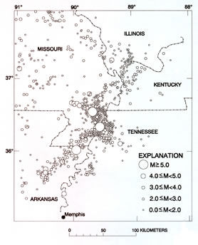
The measured locations of microseismic earthquakes indicate trends that scientist have used to identify active faults. The trends indicate a four-segment, zig-zag fault system with a total length of about 125 miles stretching from east central Arkansas northeastward through Missouri, Tennessee, Kentucky and into southern Illinois.
Location of earthquake epicenters in and near the New Madrid Seismic Zone (circles scaled according to magnitude.)
Probability
Some scientists believe the probability of a large earthquake (magnitude 7.0-8.0) is about 10% in 50 years.
Due to their infrequency, the recurrence interval of moderate to large earthquakes in the NMSZ is very hard to predict. In addition to seismic waves, scientists are using several other methods of research to better understand the fault system. While scientists cannot predict an earthquake, they can provide a Probabilistic Seismic Hazard Analysis for an area. By studying the geologic materials of the seismic zone, the stress buildup of an area and the historical record, a probability of exceedance can be calculated.
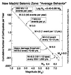
By using paleoseismology techniques scientist are able to recognize buried evidence of large prehistoric earthquakes preserved in geologic materials (soil and rock). From the approximate locations, ages and magnitudes a long term average recurrence interval can be calculated. Currently, paleoseismologists have found evidence of three or more large earthquakes (magnitude 7.0 or larger) which have occurred in the last 2,000 years. This evidence is combined with data from approximately 200 years of written history and 100 years of instrumental recordings to calculate the estimated frequency of reoccurrence or “Average Behavior.” As shown in the USGS graphic above, current modeling of the NMSZ implies a recurrence interval somewhere between 500 to 1,200 years for a major (magnitude 7.0-8.0) earthquakes. The last strong earthquake (magnitude 6.7) in the NMSZ occurred near Charleston, Missouri on Oct. 31, 1895. A magnitude 6.3 earthquake near Lepanto, Arkansas on Jan. 5, 1843 and was the next prior earthquake of this magnitude.
It must be understood that the physical evidence of past earthquakes in the NMSZ is very sparse and can be difficult to study. Scientists have made great strides in the last 50 years in understanding this complex area.
Geographic Impact
Due to the nature of the bedrock in the earth’s crust in the central United States, earthquakes in this region can shake an area approximately 20 times larger than earthquakes in California.
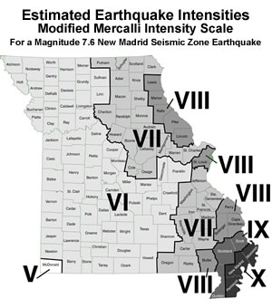
A magnitude 7.6 earthquake in the NMSZ is expected to cause major damage near the fault system in the Missouri Bootheel, northeast Arkansas and western Kentucky and Tennessee. Significant damage will likely extend north up the Mississippi River valley to St. Louis, up the Ohio and Wabash river valleys to near Owensboro, Kentucky and Indianapolis, Indiana and down the Mississippi River valley to near Greenville, Mississippi. Significant damage is also expected in of southern Illinois, western Kentucky and Tennessee, northeastern Arkansas and northwestern Mississippi as well as in areas of southeast Missouri outside the Bootheel.
Damages
The 1811-1812 earthquakes in the New Madrid Seismic Zone impacted most of the simple buildings in New Madrid and Little Prairie (Caruthersville), the two towns in the area at the time. Approximately 5,500 square miles or about 3.5 million acres of the Mississippi and Ohio river valleys were impacted by landslides, fissures, sandblows, lateral spreads, subsidence, submergence and uplift. The basic single story log buildings, which are in fact a very earthquake resistant type of construction, often shifted or sunk as parts of the areas submerged and flooded. Much of area became unusable for the subsistence type agriculture of that day. Some buildings in St. Louis, 150 miles or more to the north, received damage consisting mostly of broken or collapsed stone chimneys and broken stone buildings of Unreinforced Masonry (URM) construction. Even today those URM old buildings, which have not been retro-fitted with safety features, are especially susceptible to earthquake damage.
The primary cause of damage and injuries during an earthquake is the destruction of manmade structures and their contents. Particularly susceptible to damage from shaking are:
- Tall structures like buildings, bridges, dams
- Large Open Structures like auditoriums, classrooms, factories, hospitals, churches
- Brittle Structures like unreinforced Masonry buildings and unreinforced concrete)
- Complex Structures with odd shapes and lots of corners
- Unanchored building contents like bookshelves, file cabinets, storage racks, pipes, fire sprinkler systems, water heaters, mechanical equipment
Damage from earthquakes in the NMSZ will vary depending on the earthquakes location within the zone, magnitude, geologic nature of the material and the degree of urbanization. The Bootheel area is predominantly rural with scattered, small to medium size towns. Damage to the land by flooding, land substance and lateral spread is likely to be extensive and have a large economic impact in the area as it will disrupt farming. Thick unfertile sand deposited by sandblows and fissures can impact large areas, as fields graded for irrigation will no longer be level, drainage ditches can become blocked, and transport of materials, supplies and crops will be difficult.
While towns in the Bootheel often do not have tall structures to be damaged by shaking, there are communities that have large open structures and unreinforced masonry (URM) buildings which are likely to be impacted. Except for along the larger floodplains and areas of loose fill materials, the more distant, densely populated urban area of St. Louis is not expected to experience major damage to the land by liquefaction. However, its large number of structures and their contents likely will receive impacts from shaking.
Predicted Cost of a Seismic Event in the NMSZ
A 1991 Missouri State Emergency Management Agency (SEMA) and FEMA report estimates damages from a 7.6 magnitude NMSZ earthquake to the Bootheel counties of Mississippi, New Madrid and Pemiscot would be 0.2-2% of their population killed, 1-10% of their population seriously injured, 10% of their buildings collapsed and 30% of their buildings receiving severe structural damage. For Scott, Stoddard and Dunklin counties the percentage estimates are 0.1-1% killed, 0.5-5% seriously injured, 5% of structures collapsed and 20% with severe structural damage. For Butler, Bollinger, Cape Girardeau, Perry, St. Louis (including the city), Lincoln, Pike, Marion and Lewis Counties the estimates are 0.02- 0.2% killed, 0.1-1% seriously injured, 1% building collapses and 10% with severe structural damage.
A 2004 HAZUS report prepared by FEMA, based on a 7.7 earthquake occurring in the New Madrid Seismic Zone, estimates earthquake damages to be $296 billion dollars across the region and nearly 730,000 people displaced from their homes. In Missouri, the report estimates a direct economic loss of $69 billion dollars and nearly 87,000 damaged buildings.
Impact to Business Community
According to the Federal Emergency Management Agency (FEMA) and the QuakeSmart program, small businesses account for more than 99% of all companies in the United States, they employ 50% of all private sector workers, and provide nearly 45% of the nation’s payroll. It is estimated that 40% of all small businesses will not reopen after a major disaster and of the ones that do open 25% of those will close within one year. Developing a disaster contingency plan is essential as nearly three quarters of all companies without one will fail within three after a disaster. Small to medium sized businesses are often hit the hardest with an estimated daily income loss of $3,000 and $23,000, respectively.